
Whether you work in the aggregates, earthworks, mining, or waste management industries, making data-driven decisions is part of your daily routine. Drone surveying has never been more affordable or easier to implement on the jobsite. After taking to the skies with a drone and using 3D drone mapping software to process the data, you can access and analyze 3D models that feature accurate measurements and comprehensive GPS coordinates reflecting conditions on the ground.
Drone surveys eliminate the need for expensive, traditional base and rover surveys. After flying your drone, all you need to do is upload your data to the Propeller Aero all-in-one processing platform where drone images and flight data are transformed into interactive 3D maps that can be used for tracking progress, measuring stockpile volumes, calculating cut/fill measurements, and so much more. Read on to learn about how simple it is to build reliable, accurate 3D site models from drone data—in just five easy steps.
Choose the right drone
Adopting a drone survey program for your worksite starts with selecting the right drone. There are two main approaches to drone surveying—post-processing kinematic (PPK) workflows and real-time kinematic (RTK) workflows. The most efficient and effective survey method, though, combines the two approaches by uniting hardware, workflow, and software.
With Propeller’s PPK method, you can use an RTK-enabled drone to collect aerial data, while ground control points, such as AeroPoints, serve as a base station to collect ground-level data. After uploading your data into the Propeller Platform, it is processed accurately, delivering 3D site models you can use for bidding, project planning, and progress monitoring.
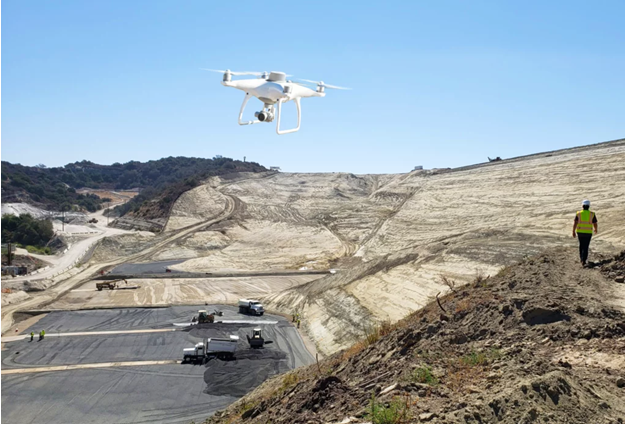
What drone works best with Propeller’s PPK drone data processing solutions? You have three categories to choose from, including:
·Fixed-wing. If you regularly work on large worksites measuring more than 500 acres, a fixed-wing drone can adequately survey your site. Fixed-wing drones have a high-quality camera that enables survey-grade accuracy within just a fraction of an inch.
·Multi-rotor. Multi-rotor drones feature a central body and several rotors that aid in maneuverability. They’re best for smaller worksites measuring under 500 acres. While they’re often the most affordable drones, they still have a high-quality camera that enables survey-grade accuracy.
·VTOL. Vertical takeoff and landing (VTOL) drones are ideal for large-scale worksites, and they have high-quality cameras that provide incredible accuracy for surveys. They take off and land vertically like multi-rotor drones but are far more efficient since they fly like fixed-wing drones.
Use ground control
As mentioned above, ground control is an essential component in drone surveying and 3D model creation. Ground control points remain in place during a survey, providing a check against the aerial images collected by the drone. They match the aerial images to a shared coordinate system, thereby locating each image’s true position on the earth. What is the advantage of using ground control points? Unmatched accuracy—as they reduce the margin of error in a survey from meters to mere centimeters.
Prepare your hardware
Before you head out to your worksite for a drone survey, make sure you’ve checked all hardware, from drone cameras to memory cards. A little preparation beforehand can save you time and minimize unanticipated roadblocks as you’re out in the field. Also ensure that you have ample charged batteries.
Calibrating your camera is an essential step in preparing for every drone survey. Even tiny adjustments to shutter speed, aperture, and gimbal angle can have a big impact on the quality of your survey images. Make sure to find the right balance of shutter speed and drone speed to prevent blurring.
Also, make sure you allow for enough overlap on images. A 75% overlap generally works best—it allows the computer to properly stitch the images together. If you’re flying your site in low-visibility conditions, or if your site lacks many distinguishing features, it’s best to increase the overlap rate so the platform can deliver an accurate model.
Fly in good weather
Before you take to the skies to survey your site, be sure to check the weather. As a general rule, don’t fly on cloudy, rainy, snowy, or windy days. It takes good weather to produce high-quality surveys. You’re not only compromising the integrity of the data you’re collecting, but you also put your valuable equipment at risk. Additionally, you could also be violating FAA regulations, including line-of-sight laws.
Invest in the best 3D drone modeling software
While it’s clear you can’t adopt a drone surveying program without a drone, you also need to invest in the right software to process the data you collect each time you fly. No matter your industry, choosing high-quality, reliable, and user-friendly software makes all the difference in the success of your surveying efforts—it’s what makes your drone data useful. Turnkey drone data processing solutions like Propeller Aero benefits teams in the aggregates, earthworks, mining, and waste management industries in several ways, including:
·Enabling progress tracking with visual timelines. With 3D models generated in the Propeller Platform, teams can easily track progress on the jobsite, and site managers can verify completion of work against design, allowing for better decision making to keep projects on track.
·Promoting sustainability. Sustainability is a key concern for professionals in the earthworks, mining, and waste management industries. 3D site models promote sustainability goals on earthworks projects by reducing rework, at mines by ensuring haul roads meet efficiency standards, and at landfills by maximizing cell lifespan.
·Streamlining communication. Propeller’s cloud-based platform makes sharing drone data easy. In a matter of clicks, you can share up-to-date site surveys with everyone involved in a project, from boardroom executives to laborers on the ground. All parties have consistent access to the information they need to make better decisions that not only keep projects on track, but also support worker safety on the jobsite.
From earthworks projects to quarries, drone survey data is transforming day-to-day workflows for the better. By flying your site and using the Propeller platform to process your data into accurate 3D models of conditions on the ground, you develop new efficiencies that enable better decision making, keeping every project on time and on budget.